Amanda DoAmaral
Riya Patel
AP Human Geography 🚜
320 resourcesSee Units
The United States has voting boundaries to make voting more representative of the population. Voting districts are set up based on population data from the census. However, many things have been done to mess with these boundaries in order to benefit different political parties.
What is an Internal Boundary?
An internal boundary is a line or border that divides one area or entity into two or more smaller areas or entities. Internal boundaries can be found in a variety of contexts, including geographic regions, political divisions, and organizational structures.
For example, an internal boundary might be a line that divides a country into states or provinces, or a line that divides a city into neighborhoods or districts. In an organizational context, an internal boundary might be a line that divides a company into different departments or divisions.
Internal boundaries can be used to define and distinguish different areas or entities within a larger whole, and they can play a role in shaping the identity and character of the smaller units that they divide.
How are Internal Boundaries Created?
Internal boundaries can be created for a variety of reasons, and the process by which they are created can vary depending on the context. Some common ways in which internal boundaries are created include:
- Political decisions: Internal boundaries are often created through political processes, such as legislation or executive action. For example, a government might pass a law that establishes new provinces or states within a country, or that divides a city into different districts or neighborhoods.
- Historical or cultural factors: Internal boundaries may be influenced by historical or cultural factors, such as the existence of pre-existing divisions or the presence of different ethnic or linguistic groups within a region.
- Physical geography: Physical geography, such as rivers, mountains, or other natural features, can sometimes serve as the basis for internal boundaries.
- Organizational needs: Internal boundaries within organizations, such as businesses or non-profits, may be created in order to facilitate the division of labor, streamline decision-making, or achieve other operational goals.
It's worth noting that internal boundaries can sometimes be contentious, and the process of creating or changing them can involve negotiation and conflict.
Examples of Internal Boundaries
Here are a few specific examples of internal boundaries:
- The Great Wall of China: The Great Wall of China is a series of walls and fortifications that were built over a period of more than 2,000 years to protect the Chinese empire from nomadic invaders. The wall serves as an internal boundary, dividing China from the steppes to the north.
- The border between the United States and Mexico: The border between the United States and Mexico is an internal boundary that divides the two countries. It was established in the 19th century through a series of treaties and agreements.
- The border between Northern Ireland and the Republic of Ireland: The border between Northern Ireland and the Republic of Ireland is an internal boundary that divides the two countries. The border was established in the 1920s as part of the partition of Ireland and has been a source of conflict and controversy.
- The boundary between departments within a company: Many companies are divided into different departments or divisions, with each department responsible for a specific area of the business. The boundaries between these departments can be considered internal boundaries.
- The border between neighborhoods within a city: Cities are often divided into neighborhoods or districts, each with its own character and identity. The boundaries between these neighborhoods can be considered internal boundaries.
Redistricting
Definition
Redistricting is the process of drawing electoral district boundaries in a representative democracy. It is typically carried out by state governments in the United States following the decennial census, in order to determine the number of seats each state has in the U.S. House of Representatives and to adjust the boundaries of legislative districts to reflect changes in population. Redistricting can have significant consequences for the balance of political power within a state and can be a controversial and politicized process.
What is the Census?
The census is a process of counting and collecting information about a population. It is typically carried out by national governments and is used to gather data on the size, composition, and distribution of a population. The census can provide valuable information about a population's age, gender, race, income, education level, and other characteristics, which can be used to inform policy decisions, allocate resources, and plan for the future.
Censuses are typically conducted every few years, and they can be conducted in a variety of ways, including through in-person visits, mailed or online surveys, or phone interviews. In some countries, participation in the census is required by law and failure to respond can result in fines or other penalties.
What Does this Do?
The census is taken every ten years to count the population for the purpose of distributing funding, resources, and to redistrict as needed. While the House of Representatives is capped at 435, the voting districts within a state have to be roughly the same size. As the population changes, the state legislature then draws new lines to accommodate a new district, which is called redistricting.
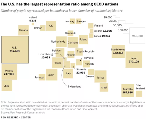
In 1912, the number of representatives was limited, which means even though the population of the US has tripled, the representation has not increased. In the US, each person in Congress represents about 747,000 people, which is significantly more than the equivalent representative in other countries.
Why is Redistricting Important?
Redistricting is typically carried out in order to reflect changes in population and to ensure that each electoral district has roughly the same number of people. This helps to ensure that each voter has an equal say in the political process and that each district is represented fairly in the government.

Source: Pew Research Center
Gerrymandering
Definition
Gerrymandering is a practice that is used to manipulate the boundaries of electoral districts in order to give an unfair advantage to a particular political party or group. This is typically done by drawing the boundaries in a way that concentrates the voters of one group into a small number of districts, while spreading out the voters of the other group into many districts. As a result, the group that has been "gerrymandered" is unable to win as many seats as it otherwise would have been able to, based on its share of the vote. Gerrymandering is generally seen as undemocratic and has been the subject of legal challenges in many countries.
The process of redistricting can lead to dramatic manipulations. The most well-known example of this is gerrymandering, which when politicians use redistricting to cement their power. This is often based on race, voting patterns, class, etc.
For example, if there is a huge population of liberal black voters in a district, they would win seats as they outvote conservative white voters. But if you split the district through the black population, now you could have two districts with a majority of white conservative voters and minority black liberal voters. By doing this, there would now be two conservative congress-people representing an area that is actually a majority liberal area.
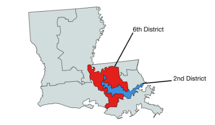
Here’s an example in Louisiana. The largest cities of Baton Rouge and New Orleans have the biggest black population in the state. The 6th District was drawn to keep the wealthy, white neighborhoods surrounding the two cities, while black communities are included in the 2nd District, which is largely liberal. By doing this, the 6th remains Republican and the 2nd is the only safely blue district in the state. If these lines were drawn differently, both districts could be overwhelmingly blue.
Why is Gerrymandering Important?
Gerrymandering is important because it can have significant consequences for the balance of political power within a state or country. By manipulating district boundaries, political parties can try to ensure that they win a disproportionate number of seats in the government, even if they do not have the support of a majority of voters. This can lead to a situation where the preferences of the majority of voters are not reflected in the makeup of the government, and can undermine the legitimacy of the political process.

Source: Louisiana
Types of Gerrymandering
There are five types of gerrymandering and they all rhyme! Cracking, packing, stacking, hijacking, and kidnapping.
Cracking is when legislatures disperse a group into several districts in order to prevent a majority. Packing combines similar voters into one district to prevent them from affecting another district. This is what we see in Louisiana. Stacking is when minority voting groups are “stacked” together, but alongside higher turnout majority groups which dilutes their power. Hijacking involves redrawing districts to force two representatives in the same party to run against each other. And kidnapping is when redistricting moves a supported elected official to an area they are no longer supported.
Summary of Gerrymandering Types
Here are some common ways that gerrymandering can occur:
- "Cracking" refers to the practice of dividing a group of voters into multiple districts in order to dilute their voting power.
- "Packing" refers to the practice of concentrating a group of voters into a single district in order to reduce their influence in other districts.
- "Stacking" refers to the practice of creating districts with a narrow majority of voters from one group, in order to create a larger number of districts where that group has a minority of voters.
- "Hijacking" refers to the practice of altering district boundaries to move a group of voters into a different district, in order to change the outcome of an election.
- "Kidnapping" refers to the practice of altering district boundaries to move a group of voters into a district with a different representative, in order to change the outcome of an election.
Overall, any boundary has consequences, whether positive or negative. For example, when people who speak the same language or practice the same religion are split, boundaries play a negative role. But in a situation where two entities who are conflicting over a piece of land create a boundary that satisfies both parties, boundaries can be positive as well.
🎥 Watch: AP HUG - Shapes of States
Browse Study Guides By Unit
🗺Unit 1 – Thinking Geographically
👪Unit 2 – Population & Migration
🕌Unit 3 – Cultural Geography
🗳Unit 4 – Political Geography
👨🌾Unit 5 – Agriculture & Rural Land-Use
🌇Unit 6 – Cities & Urban Land-Use
💸Unit 7 – Industrial & Economic Development
🧐Exam Skills
📚Study Tools

Fiveable
Resources
© 2025 Fiveable Inc. All rights reserved.