Harrison Burnside
Riya Patel
AP Human Geography 🚜
320 resourcesSee Units
City Models
City models are theoretical frameworks used in urban sociology to describe the way in which cities grow and develop. These models are based on observed patterns of urbanization and are intended to help us understand the complex processes that shape the physical, social, and economic structures of cities.
City models are often used to explain the way in which different social and economic groups are distributed within a city, and how the various parts of the city are connected to one another. They can also be used to analyze the impacts of different planning and policy decisions on the growth and development of cities.
There are several different city models that have been developed over the years, each with its own unique perspective on the way in which cities grow and change. Some of the most well-known city models include the concentric zone model, the Hoyt Sector Model, the Multiple Nuclei Model, and the peripheral model. These models are useful tools for understanding the complex dynamics of urban life, and can help us to identify trends and patterns that may not be immediately apparent from casual observation.
In APHuG, city models are important because they provide a way to understand and analyze the complex processes that shape the growth and development of cities. They allow us to identify patterns and trends in the way that cities change over time, and can help us to understand the factors that contribute to these changes.
City models are also important because they can help policymakers and planners to understand the impacts of different planning and policy decisions on the growth and development of cities. By analyzing the way in which different city models describe the relationships between different parts of the city and the way in which they change over time, policymakers and planners can make informed decisions about how to shape the future growth and development of cities in a way that is sustainable, equitable, and livable.
Overall, city models are an important tool for understanding the complexities of urban life, and for making informed decisions about how to shape the future of our cities.
Concentric Zone Model
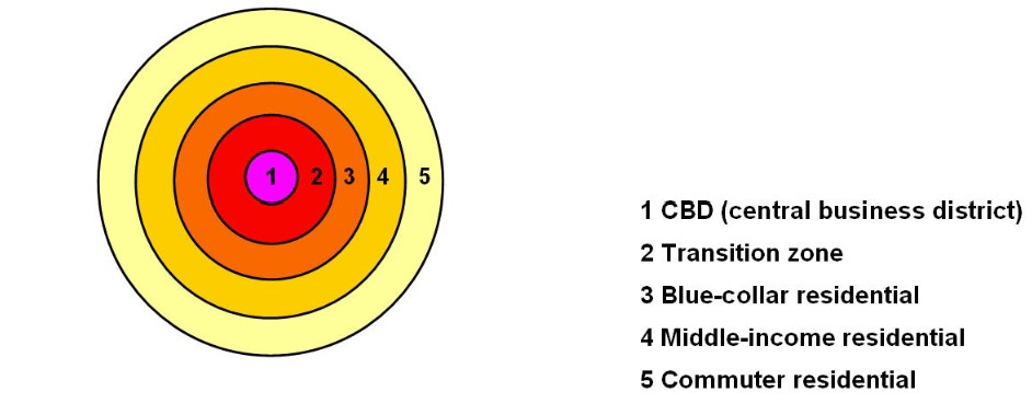
The concentric zone model, also known as the Burgess model or the Chicago School model, is a model used in urban sociology to describe the way in which cities grow and develop. According to the concentric zone model, cities grow outward from a central business district (CBD) in a series of concentric circles, with each successive ring representing a different stage of development.
The concentric zone model is based on the idea that cities tend to develop in a predictable pattern, with the most densely populated and developed areas located in the center, and the least densely populated and developed areas located on the outskirts. The model is often used to explain the way in which different social and economic groups are distributed within a city.
Here are some key points about the concentric zone model:
- The concentric zone model, also known as the Burgess model or the Chicago School model, is a model of urban land use and urban social structure. It was developed by sociologist Ernest Burgess in the 1920s.
- The model proposes that cities grow outward from a central business district in a series of concentric zones, with each successive zone having a different character and social structure. The central business district is surrounded by a ring of inner-city neighborhoods, which are in turn surrounded by a ring of suburban neighborhoods.
- According to the model, the inner-city neighborhoods are characterized by high levels of poverty, crime, and social disorganization, while the suburban neighborhoods are characterized by affluence and social stability.
- The model suggests that social and economic characteristics tend to be more homogeneous within each zone, and that people living in a particular zone are more likely to have similar backgrounds and lifestyles.
- The concentric zone model has been criticized for oversimplifying the complex social and economic dynamics of urban areas and for not adequately accounting for racial and ethnic segregation.

Source: https://cronodon.com/PlanetTech/Cities_Structure.html
Hoyt Sector Model
The Hoyt Sector Model is another model used in urban sociology to describe the way in which cities grow and develop. It was developed by American urban planner Homer Hoyt in 1939 as an alternative to the concentric zone model, which was the dominant model of urban growth at the time.
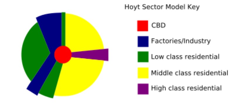
Unlike the concentric zone model, which posits that cities grow outward in a series of concentric circles, the Hoyt Sector Model proposes that cities grow in a series of sectors, with each sector representing a different stage of development. According to the Hoyt Sector Model, cities grow outward from a central business district (CBD) in a series of wedges, with the most densely populated and developed areas located in the center, and the least densely populated and developed areas located on the outskirts.
The Hoyt Sector Model is often used to explain the way in which different social and economic groups are distributed within a city, with wealthier residents tending to live in the inner sectors and poorer residents tending to live in the outer sectors. It has been widely influential in the field of urban sociology, and has been used to study the development of cities around the world.
The Hoyt Sector Model is a model of urban land use and urban social structure that was developed by economist Homer Hoyt in the 1930s. Here are some key points about the Hoyt Sector Model:
- The Hoyt Sector Model proposes that cities grow outward from a central business district in a series of sectors, with each sector having a distinct character and social structure.
- The model suggests that the location and type of land use within a sector is determined by a combination of transportation accessibility, land availability, and social and economic factors.
- According to the model, the central business district is the most desirable location for business and commercial activities, due to its high levels of accessibility and land value.
- The model also proposes that the outer regions of a city are less desirable for business and commercial activities, due to their lower levels of accessibility and land value. These outer regions are typically characterized by residential land use.
- The Hoyt Sector Model has been criticized for oversimplifying the complex social and economic dynamics of urban areas and for not adequately accounting for racial and ethnic segregation.

Source: https://en.wikipedia.org/wiki/Sector_model#/media/File:Hoyt_model.svg
Multiple Nuclei Model
The Multiple Nuclei Model is a model used in urban sociology to describe the way in which cities grow and develop. It was developed by American urban planners Chauncy Harris and Edward Ullman in 1945 as an alternative to the concentric zone model and the Hoyt Sector Model, which were the dominant models of urban growth at the time.
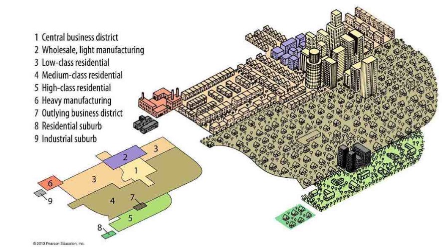
Unlike the concentric zone model and the Hoyt Sector Model, which posit that cities grow outward from a single central business district (CBD) in a series of concentric circles or sectors, the Multiple Nuclei Model proposes that cities grow and develop around multiple centers, or nuclei, each with its own unique characteristics and functions. According to the Multiple Nuclei Model, cities are not homogenous entities, but rather are composed of a variety of different zones, each with its own distinct character and functions.
The Multiple Nuclei Model is often used to explain the way in which different social and economic groups are distributed within a city, and how the various centers or nuclei within the city are connected to one another. It has been widely influential in the field of urban sociology, and has been used to study the development of cities around the world.
The Multiple Nuclei Model is a model of urban land use and urban social structure that was developed by geographer C.D. Harris and economist E.L. Ullman in the 1945. Here are some key points about the Multiple Nuclei Model:
- The Multiple Nuclei Model proposes that cities are composed of multiple centers or "nuclei" of land use, rather than a single central business district.
- These nuclei can be centered around various activities such as commerce, industry, or transportation, and can vary in size and importance.
- The model suggests that the location and type of land use within a city is determined by a combination of transportation accessibility, land availability, and social and economic factors.
- According to the model, the distribution of land use and population within a city is not necessarily tied to a single center or nucleus, but is instead influenced by the interplay of multiple nuclei and the transportation networks connecting them.
- The Multiple Nuclei Model has been influential in shaping our understanding of urban land use and has been influential in planning and policy decisions. However, it has also been criticized for oversimplifying the complex social and economic dynamics of urban areas and for not adequately accounting for racial and ethnic segregation.

Source: Pearson Realize Prentice Hall Textbook
Peripheral Model - “Edge Cities”
The peripheral model, also known as the "edge city" model, is a model used in urban sociology to describe the way in which cities grow and develop. The term "edge city" was coined by American journalist Joel Garreau in his 1991 book "Edge City: Life on the New Frontier," in which he described a new type of city that was emerging on the outskirts of metropolitan areas in the United States.
According to the peripheral model, edge cities are large, sprawling developments that are located on the outskirts of metropolitan areas and are characterized by their proximity to major transportation corridors, such as highways and airports. These developments often include a mix of residential, commercial, and industrial areas, and are often home to large numbers of white-collar workers who commute to the city center for work.
Edge cities are often seen as a response to the increasing decentralization of population and economic activity in metropolitan areas, and are considered to be a distinctive feature of contemporary urban landscapes. They are often described as being more decentralized and less densely populated than traditional cities, and are often characterized by their car-dependent nature and lack of public transportation.
The "peripheral model" or "edge city" is a term used to describe a concentration of office, retail, and entertainment development outside of a city's central business district (CBD). Edge cities are often located at the intersections of major highways and have emerged as a result of decentralization of jobs and population from traditional urban cores.
Some key points about edge cities include:
- They are often located in suburban areas, but can also be found in smaller towns and rural areas.
- They are characterized by a mix of uses (e.g. office, retail, entertainment) and a high degree of car dependence.
- They tend to have a more decentralized and dispersed development pattern than traditional CBDs.
- They are often self-contained, with a range of amenities and services available within the edge city itself, rather than requiring residents to travel to the urban core.
- They can function as regional centers, serving a large area beyond the immediate locality.
- They are sometimes seen as a threat to traditional downtowns, as they can divert investment and development away from the urban core. However, they can also provide economic benefits and increase accessibility for residents who live further from the city center.

Source: Pearson Realize Prentice Hall Textbook
Summary
There are several different models that have been developed in urban sociology to describe the way in which cities grow and develop. Some of the most well-known city models include:
- The concentric zone model: This model proposes that cities grow outward from a central business district (CBD) in a series of concentric circles, with the most densely populated and developed areas located in the center and the least densely populated and developed areas located on the outskirts.
- The Hoyt Sector Model: This model proposes that cities grow outward from a CBD in a series of sectors, with the most densely populated and developed areas located in the center and the least densely populated and developed areas located on the outskirts.
- The Multiple Nuclei Model: This model proposes that cities grow and develop around multiple centers, or nuclei, each with its own unique characteristics and functions.
- The peripheral model: This model, also known as the "edge city" model, proposes that large, sprawling developments on the outskirts of metropolitan areas are becoming a distinctive feature of contemporary urban landscapes.
These models are useful tools for understanding the way in which cities grow and change over time, and can help us to understand the social, economic, and spatial patterns that shape urban life.
Browse Study Guides By Unit
🗺Unit 1 – Thinking Geographically
👪Unit 2 – Population & Migration
🕌Unit 3 – Cultural Geography
🗳Unit 4 – Political Geography
👨🌾Unit 5 – Agriculture & Rural Land-Use
🌇Unit 6 – Cities & Urban Land-Use
💸Unit 7 – Industrial & Economic Development
🧐Exam Skills
📚Study Tools

Fiveable
Resources
© 2025 Fiveable Inc. All rights reserved.